the laboratory
The laboratory is focused on the development of innovative applications of satellite/aerial optical (multi- and hyper-spectral) and SAR imagery covering a wide range of fields of interest, as fire monitoring, volcanic eruptions and ash cloud monitoring, oil spill monitoring, environmental monitoring including the development of applications related to security. The laboratory is oriented in particular to the development of automatic applications based on real-time approaches.
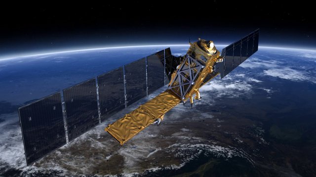
Equipped with software and hardware instruments, and with a wide dataset of satellite images including low as well as very high spatial resolution, both optical and radar, the laboratory relies on two satellite image acquisition systems: one located in Rome, and another one in the Broglio Space Center in Malindi, Kenya.
Rome Station acquires images from SEVIRI (Spinning Enhanced Visible and Infrared Imager), on board Meteosat Second Generation (MSG) satellite, and images from MODIS and AVHRR satellites, while Malindi Station could acquire high resolution images (Landsat, CBERS, etc.)

INSTRUMENTS TO SUPPORT FIELD CAMPAIGNS
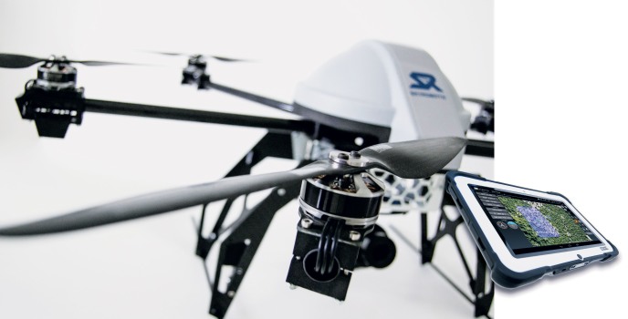
SkyRobotics VTOL SF6
The Vertical Take-Off and Landing is a UAS platform designed to perform aerial reconnaissance at a fixed point. Especially suitable to perform flight plans in areas marked by a complex orography, it can perform timely, safe and accurate surveys. The onboard Skyrobotic autopilot grants a precise automatic GPS navigation and allows the manual override of the multirotor at any time. The proprietary software SkyDirector installed on a rugged tablet PC allows the definition of an accurate automatic navigation path based on waypoints.
The system has multiple mission planning criteria, allowing the operatorto select the most suitable ones for each mission.
-
Advanced automatic tools for easy planning 2D and 3D surveing.
-
Complete automatic GPS navigation through way points that can be changed in live during the mission.
-
Unique RTK VTOL integration for centimeter geolocalization.
-
Unique tecnology: Target traking, Mission simulator, DataLink interoperability.
-
Loitering touch and go and rally waypoints selectable.
-
Onpoint target tracking in stable loitering waypoint and manual navigation mode.
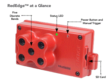 MICASENSE RedEdge: Is an advanced multispectral camera specially designed for small unmanned aircraft systems. It provides accurate multiband data for agricultural remote sensing. RedEdge is powered by MicaSense, Inc., a team of data-collection leaders with decades of expertise in a variety of unmanned aerial vehicle (UAV) applications. MicaSense is redefining remote sensing technology and pioneering a new way to harvest information.
- Spectral Bands: Blue, green, red, red edge, near IR (narrowband)
- Ground Sample Distance: 8 cm per pixel (per band) at 120 m (~400 ft) AGL
- Capture Rate: 1 capture per second (all bands), 12-bit RAW
- Field of View: 47.2 o HFOV
|
|
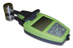
DUALEX SCIENTIFIC+
polyphenol & chlorophyll-meter
|
LAI 2200 C
Plant Canopy Analyser
|
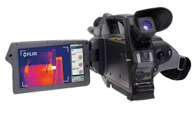
FLIR ThermaCAM SC660
|
|||||||||||||||||
|---|---|---|---|---|---|---|---|---|---|---|---|---|---|---|---|---|---|---|---|---|
|
|
 |
|
|
|||||||||||||||||
|
|
Based on research of the CNRS (National Center for Scientific Research) and the University of Paris-Sud Orsay, this new leaf-clip can simultaneously and accurately monitor the chlorophyll content in leaves, flavonol and anthocyanin contents in the epidermis. Versatile, it is dedicated to plant science and agronomy. Applied equally on monocots, dicots or perennials, this tool is simple to use. Measurements are instantaneous and non-destructive. (read more...) |
The LAI-2200 calculates Leaf Area Index (LAI) and other canopy attributes from light measurements made with a “fish-eye” optical sensor (148° field-of-view). Measurements made above and below the canopy are used to calculate canopy light interception at five zenith angles, from which LAI is computed using a model of radiative transfer in vegetative canopies. (read more...)
|
FLIR SC660 is a high performance infrared system used for science and research applications within the long wave spectral range. With its 640x480 resolution it produces sharp images with high accuracy radiometric readings. Camera portability increases the flexibility of use. A Firewire port is available for real time image transfer to PC for data capture and analysis. The camera is equipped with the standard 24° lens. (read more...)
|
|||||||||||||||||


In cooperation with CNR - IMAA (Centro Nazionale delle Ricerche - Istituto di Metodologie per l'Analisi Ambientale)
-
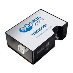 OCEAN OPTICS USB 2000:
  USB2000+ (Custom) spectrometer is a versatile, general-purpose UV-Vis-NIR spectrometer for absorption, transmission, reflectance, emission, color and other applications. This popular spectrometer can be custom-configured for maximum flexibility (read more...).
-
FIELDSPEC FRpro Spectroradiometer : The FieldSpecFR spectroradiometer has a sampling interval of 2 nm and a spectral resolution of 10 nm, which meet the nominal sampling and resolution requirements for hyperspectral remote sensing applications. Spectral sampling interval is the spacing between sample points in the spectrum. Sampling is independent of resolution and in ASD spectroradiometers is between 2 and 5 times per FWHM. The sampling interval for the FieldSpecFR is 1.4 nm for the region 350 - 1000 nm and 2 nm for the region 1000 - 2500 nm. Spectral resolution is defined as the full-width-half-maximum (FWHM) of the instrument response to a monochromatic source. This is in fact the definition ASD uses when stating spectral resolution specifications. The FWHM spectral resolution of the FieldSpecFR spectroradiometer is 3 nm for the region 350 - 1000 nm and 10 nm for the region 1000 - 2500 nm. These spectral resolution values have been measured by calculating the FWHM of a near monochromatic peak in a spectrum acquired when viewing the output of a monochromator with the FieldSpecFR spectroradiometer (read more...).
-
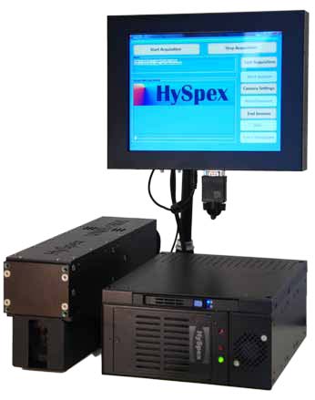
 Hyspex1600: This sensor operates in the visible and near infrared (VNIR) spectral range between 400 – 1000 nm. The spectral bands can be customized based upon application. Up to 160 bands can be configured using a spectral sample of 3.7 nm. Resolution of a pixel on the ground is dependent on the selected acquisition altitude; for example at flight altitude of 1500 m the pixel size is 1.0 m and at 2500 m altitude the pixel size is 1.9 m. Applications for the Hyspex VNIR-1600 include but are not limited to: Habitat Mapping (marine, aquatic and terrestrial), Water Clarity Mapping, Forestry Mapping, Agricultural Mapping, Urban planning/management (read more...).
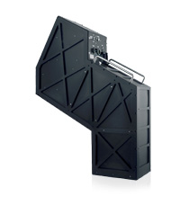
 TASI 600: Is an hyperspectral thermal sensor system designed specifically for airborne use. Available in a 32 spectral channel configuration, with a spectral range of 8 to 11.5 microns, and featuring 600 spatial pixels, it is well suited to numerous critical applications including mining exploration, geophysical mapping, and landmine & ordnance detection. (read more...).
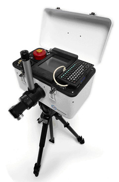
 FT-IR Spectrometer Model 102: This hand portable, remote sensing field and industrial instrument is lighter and more versatile than our Model 101, which has served the research needs of scientists and engineers worldwide since 1991 (read more...).